ORDINANCE 840
ORDINANCE 840
AN ORDINANCE TO AMEND THE MILBANK MUNICIPAL CODE REGARDING WARD BOUNDARIES WITHIN THE CITY OF MILBANK.
BE IT ORDAINED BY THE CITY COUNCIL OF THE CITY OF MILBANK, GRANT COUNTY, SOUTH DAKOTA, that Chapter 1.03 of the Milbank Municipal Code be amended to read as follows:
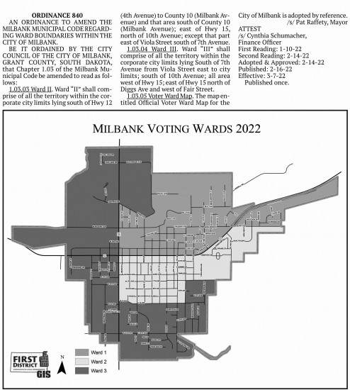
1.03.03 Ward II. Ward “II” shall comprise of all the territory within the corporate city limits lying south of Hwy 12 (4th Avenue) to County 10 (Milbank Avenue) and that area south of County 10 (Milbank Avenue); east of Hwy 15, north of 10th Avenue; except that part east of Viola Street south of 7th Avenue.
1.03.04 Ward III. Ward “III” shall comprise of all the territory within the corporate city limits lying South of 7th Avenue from Viola Street east to city limits; south of 10th Avenue; all area west of Hwy 15; east of Hwy 15 north of Diggs Ave and west of Fair Street.
1.03.05 Voter Ward Map. The map entitled Official Voter Ward Map for the City of Milbank is adopted by reference.
/s/ Pat Raffety, Mayor
ATTEST
/s/ Cynthia Schumacher,
Finance Officer
First Reading: 1-10-22
Second Reading: 2-14-22
Adopted & Approved: 2-14-22
Published: 2-16-22
Effective: 3-7-22